Overview
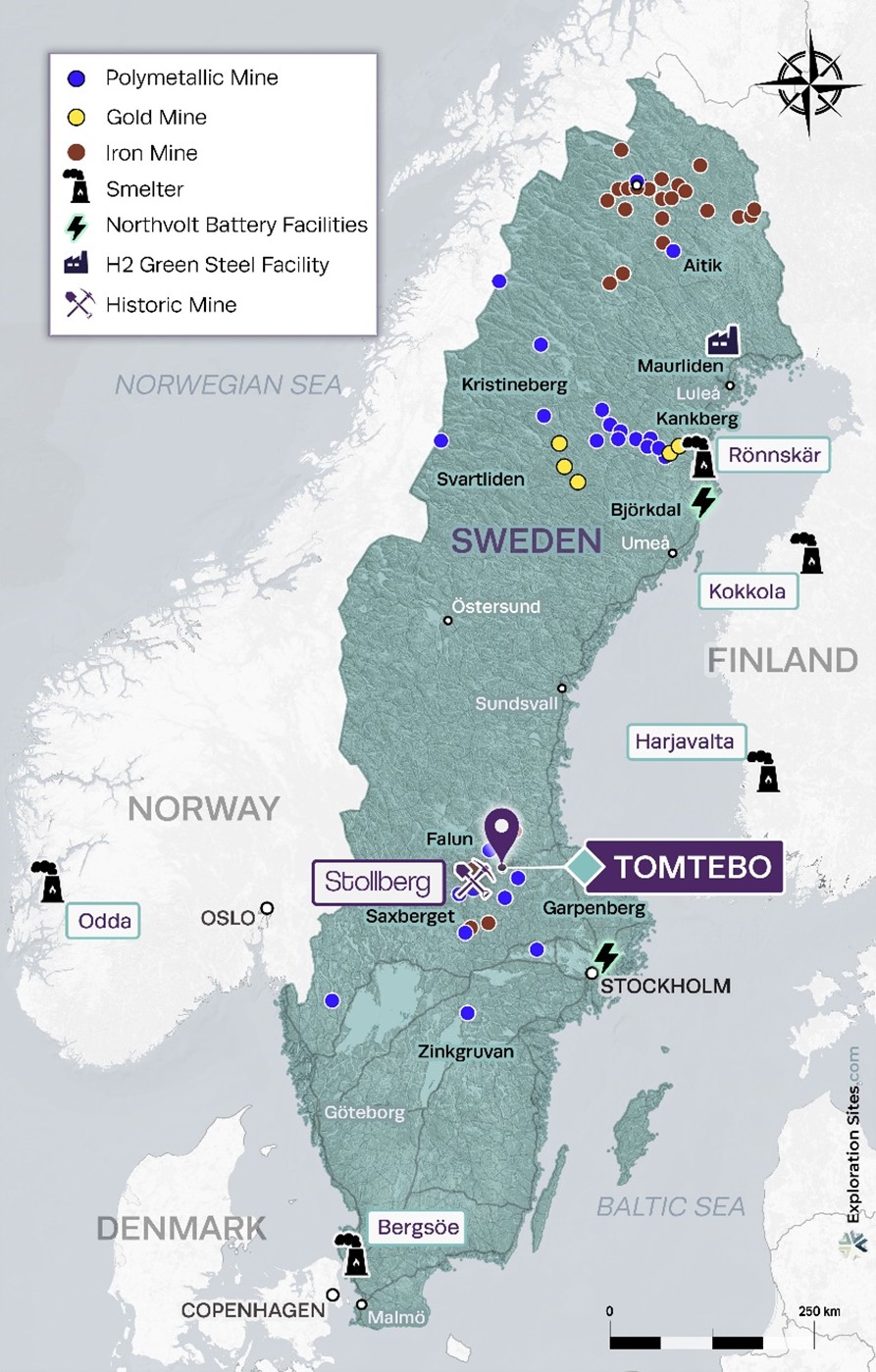
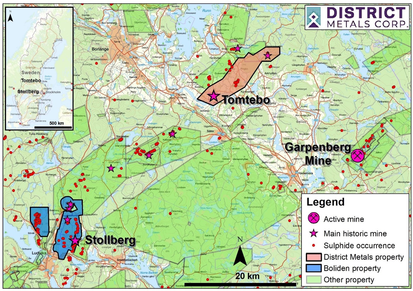
In October 2023, District and Boliden entered into a Definitive Agreement whereby both companies will collaborate in the development of District’s wholly-owned polymetallic Tomtebo Property and Boliden’s wholly-owned polymetallic Stollberg Property. The definitive agreement entails Boliden spending CDN$10.0M over four years, and District is the operator where Boliden will earn up to 85% of Tomtebo and District will earn up to 15% of Stollberg. The Tomtebo and Stollberg Properties (Figures 1 and 2) are located 35 km apart along a well-known metallogenic belt in the heart of the prolific Bergslagen Mining District in Sweden, which hosts Boliden’s Garpenberg Mine and Lundin Mining’s Zinkgruvan Mine.
Tomtebo Property Highlights
- Tomtebo covers an area of 5,144 hectares (ha) and is located 175 km northwest from the capital city of Stockholm in Sweden (Figure 1).
- Boliden’s Garpenberg Mine is located 25 km to the southeast, and the historic Falun Mine is located 25 km to the northwest. Lundin Mining’s Zinkgruvan Mine is located 175 km to the southwest.
- Tomtebo contains similar host rocks, structure, alteration, and mineralization styles as the Garpenberg, Falun, and Zinkgruvan Mines.
- Two historic mines, and numerous mineralized prospects are situated along a 17 km trend on the property. Mineralization at the historic Tomtebo and Lovas Mines appears to be open in all directions.
- Historic production at the Tomtebo Mine comprised 120,000 tonnes at 4.4% Cu3. Historic production at the Lovas Mine comprised 330,000 tonnes at 3.5% Zn, 2.5% Pb, and 30g/t Ag2.
- Modern systematic exploration was initiated on the Tomtebo Property in 2020 by District.
- District drill intercepts from 2021 and 2022 campaigns at the Tomtebo Property include:
- TOM21-001 intersected 8.2 m at 20.9% ZnEq11 (10.3% Zn, 4.5% Pb, 66.2 g/t Ag, 1.7 g/t Au, and 0.08% Cu) from 65.3 to 73.5 m;
- TOM21-002 intersected 12.55 m at 8.6% ZnEq11 (148.6 g/t Ag, 2.1% Zn, 2.2% Pb, 0.2 g/t Au, and 0.04% Cu) from 90.8 to 103.35 m;
- TOM21-013 intersected 8.65 m at 3.6% CuEq12 (2.92% Cu and 0.43 g/t Au) from 76.65 to 85.3 m;
- TOM21-019 intersected 9.8 m at 2.34% CuEq12 (1.1% Cu and 0.61 g/t Au) from 69.5 to 79.3 m;
- TOM21-025 intersected 14.3 m at 14.2% ZnEq11 (9.5% Zn, 40.0 g/t Ag, 2.3% Pb, 0.4 g/t Au, and 0.2% Cu) from 210.0 to 224.3 m;
- TOM21-028 intersected 30.05 m at 10.9% ZnEq11 (7.0% Zn, 25.0 g/t Ag, 1.9% Pb, 0.4 g/t Au, and 0.2% Cu) from 148.35 to 178.40 m;
- TOM22-038 intersected 25.5 m at 8.2% ZnEq11 (2.4% Zn, 65.0 g/t Ag, 2.1% Pb, 0.6 g/t Au, and 0.2% Cu) from 249.0 to 274.1 m.
Stollberg Property Highlights
- The Stollberg Property covers an area of 5,180 ha and is located 180 km northwest of the capital city of Stockholm in Sweden (Figure 1).
- Boliden’s Garpenberg Mine is located 50 km to the east, and the historic Falun Mine is located 50 km to the north. Lundin Mining’s Zinkgruvan Mine is located 150 km to the south.
- The Stollberg Mineralized Trend has been mined from the 14th century until 1982 and yielded 6.65 Mt of iron, and zinc-lead-silver ore, comprising semi-massive to massive magnetite and base metal sulphides bodies spatially related to skarn and altered carbonate rocks13,14,15.
- Boliden has been actively exploring the Stollberg Property since 2000 and has drilled on multiple geological and geophysical targets, including the discovery of Västansjö in 2013.
- The Stollberg Property includes two mining concessions:
- Gränsgruvan K nr 1, which covers the historic Gränsgruvan Mine (1943-1978) with polymetallic mineralization;
- Västansjö K nr 1 covers a published (February 25, 2016)16 Historical Mineral Resources of:
- Historical Inferred Mineral Estimate: 235,000 tonnes grading 3.35% Zn, 2.27% Pb, 30 g/t Ag, 0.08% Cu, 0.11 g/t Au.
- Historical Indicated Mineral Estimate: 621,000 tonnes grading 3.76% Zn, 2.11% Pb, 32 g/t Ag, 0.26% Cu, 0.13 g/t Au.
- The Stollberg Property contains similar host rocks, structure, alteration, and mineralization styles as the Garpenberg Mineralized Trend, which gives significant support in making a similar new discovery13,14,15.
Figure 1: Location Map
Bergslagen Mining District
The Bergslagen District is composed largely of supracrustal rocks dominated by felsic metavolcanic successions with limestones and calcsilicates, along with pre- to post-tectonic intrusive rocks located in south central Sweden. The region was folded and metamorphosed to upper amphibolite facies during the Svecofennian orogeny (1.9 to 1.8 Ga).
The district hosts thousands of mineral occurrences, including polymetallic Zn-Pb-Ag-Cu-Au sulphide and iron oxide deposits, Fe oxide skarn, banded iron formation, Fe oxide apatite, Mn oxide, and subordinate granite-pegmatite–hosted molybdenite and W skarn deposits1.
Figure 2: Bergslagen Mining District
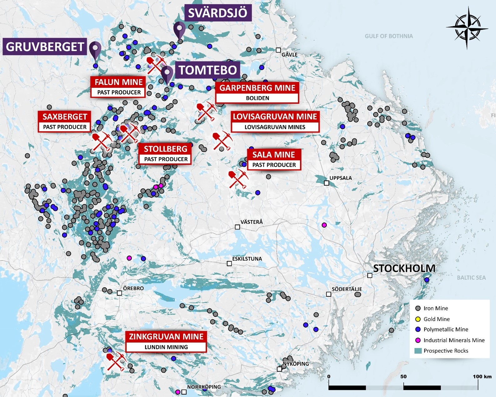
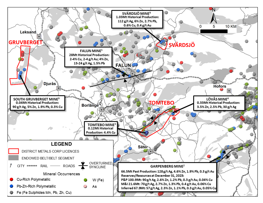
Table 1: Bergslagen District Production, Reserves, and Resources
| Mine/Deposit | Tonnage of Production, Reserve, or Resource with Grades |
| Falun Mine1 | 28.1 Mt Production at 2–4% Cu, 2-4 g/t Au, 4% Zn, 1.5% Pb, 13–25 g/t Ag |
| Garpenberg Mine2 | 66.5 Mt Production at 128 g/t Ag, 4.6% Zn, 1.9% Pb, 0.3 g/t Au |
| Garpenberg Mine2 | 100.9 Mt P&P at 90 g/t Ag, 2.6% Zn, 1.2% Pb, 0.3 g/t Au, 0.04% Cu |
| Garpenberg Mine2 | 21.6 Mt M&I at 70 g/t Ag, 2.7% Zn, 1.3% Pb, 0.4 g/t Au, 0.06% Cu |
| Garpenberg Mine2 | 67.9 Mt Inferred at 57 g/t Ag, 2.3% Zn, 1.1% Pb, 0.3 g/t Au, 0.05% Cu |
| Tomtebo Mine3 | 0.12 Mt Production at 4.4% Cu |
| Lovas Mine4 | 0.33 Mt Production at 3.5% Zn, 2.5% Pb, 30g/t Ag |
| Zinkgruvan Mine5 | 19.3 Mt Production at 9.9% Zn, 4.0% Pb, 84 g/t Ag 0.9 Mt Production at 2.0% Cu |
| Zinkgruvan Mine5 | 11.9 Mt P&P at 7.9% Zn, 2.9% Pb, 63 g/t Ag |
| Zinkgruvan Mine5 | 5.2 Mt P&P at 1.8% Cu, 0.2% Zn, 26 g/t Ag |
| Zinkgruvan Mine5 | 15.7 Mt M&I at 9.3% Zn, 3.7% Pb, 84 g/t Ag |
| Zinkgruvan Mine5 | 5.0 Mt M&I at 2.3% Cu, 0.3% Zn, 32 g/t Ag |
| Zinkgruvan Mine5 | 9.4 Mt Inferred at 8.5% Zn, 3.5% Pb, 81 g/t Ag |
| Zinkgruvan Mine5 | 0.2 Mt Inferred at 2.3% Cu, 0.3% Zn, 25 g/t Ag |
| Sala Mine1 | 5.0 Mt Production at 150-3000 g/t Ag, 12% Zn, 1.5% Pb |
| Stollberg (Gransgruvan Mine)6 | 6.7 Mt Production at 7.7% Zn, 2.6% Pb, 60 g/t Ag |
| Stollberg (Tvistbo Mine)7 | 0.58 Mt Production at 3.3% Zn, 2.6%, 22 g/t Ag |
| Saxberget Mine3 | 6.43 Mt Production at 42.2 g/t Ag, 0.4 g/t Au, 0.9% Cu, 2.2% Pb, 7.1% Zn |
| Lovisagruvan Mine8 | 1.15 Mt Production at 9.4% Zn, 5.3% Pb, 10-20 g/t Ag |
Note: The nearby mines provide geologic context for District’s Project, but this is not necessarily indicative that the Project hosts similar tonnages or grades of mineralization.
Figure 3: Northern Bergslagen Mining District
Background on the Tomtebo Property
Mining on the Tomtebo Property can be traced back to the mid-seventeenth century. Two historic mines, and numerous mineralized prospects are situated along more than a 17 km trend on the property. Historic production at the Tomtebo Mine comprised 120,000 tonnes at 4.4% Cu3, and historic production at the Lövås Mine comprised 330,000 tonnes at 3.5% Zn, 2.5% Pb, and 30g/t Ag4. Mining depths reached down to approximately 200 m, and based on available cross sections and long sections, mineralization at the historic Tomtebo and Lövås Mines appears to be open in all directions. Comparatively, mining operations at Boliden’s Garpenberg Mine and Lundin’s Zinkgruvan Mine are currently at depths of 1400 m and 1270 m, respectively.
Tomtebo Mine
State owned Stora AB (Stora) conducted development drilling in the 1960’s and 1970’s from exploration drifts at the 200 m level that was used to estimate a historic resource in 1983 from surface to 200 m depth at the historic Tomtebo Mine comprised 385,000 tonnes grading 0.67% Cu, 1.84% Pb, 3.72% Zn, 0.66 g/t gold, and 55 g/t Ag10. This is a historic resource estimate for the purposes of NI 43-101, and a Qualified Person has not done sufficient work to classify the historic estimate above as current mineral resources or mineral reserves, and District is not treating the historical estimate as current mineral resources or mineral reserves. This historic resource was estimated in 1983 by Birger Hellegren in a Technical Report on the Tomtebo Mine, and it does not include any categories prescribed by NI 43-101. The key assumptions, parameters and methods used to prepare the historical estimate are not known. The Company is not aware of any more recent estimates or data relating to the historical estimate. District Metals considers these results as indications of the presence of mineralization on the property and will use the information to guide future exploration.
The Oscarsgruvan zone is situated at the north end of the Tomtebo Mine and is dominated by silver-zinc-lead mineralization with lesser copper-gold mineralization. The holes highlighted in Figures 4 and 5 accompanied by Table 2 below show strong mineralization associated with semi-massive and massive sulphides over a dip extent of 200 m and strike extent of 170 m that remains open.
Figure 4: Plan View of Tomtebo Mine
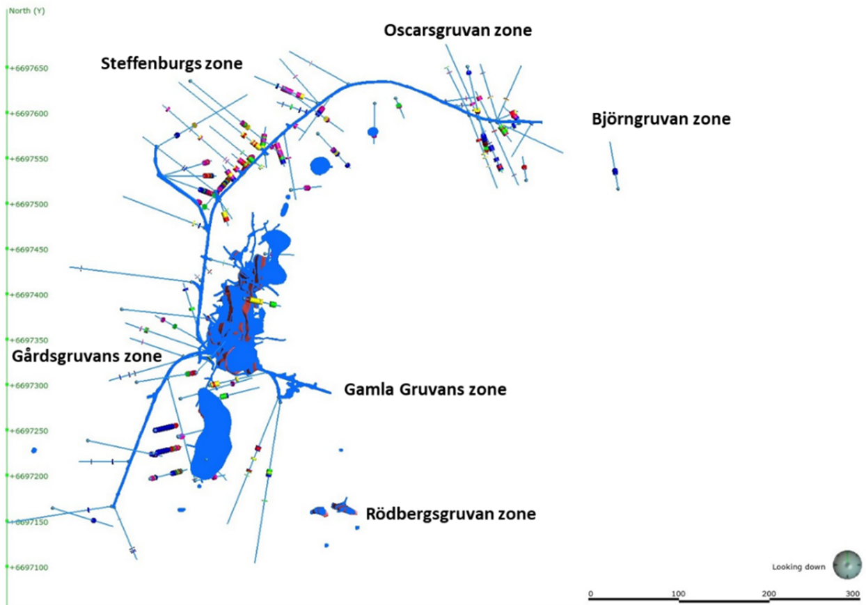
Figure 5: Long Section Facing South from North End of Tomtebo Mine
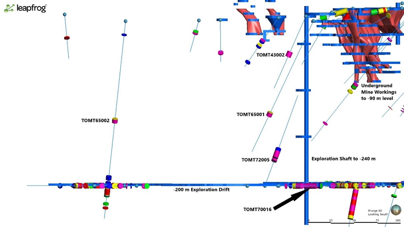
Table 2: Oscarsgruvan Zone Historical Drill Results
| Drill Hole | Depths and Interval | Historical Assay Results | |||||||||||
| Hole ID | Azimuth | Dip | Hole Type | From (m) | To (m) | Interval (m) | Ag (g/t) | Au (g/t) | Cu (%) | Zn (%) | Pb (%) | AgEq (g/t) | ZnEq (%) |
| TOMT65001 | 127 | -60 | Surface | 113.90 | 118.57 | 4.67 | 199.84 | 0.88 | 0.25 | 13.64 | 6.93 | 934.80 | 23.85 |
| TOMT65002 | 167 | -65 | Surface | 116.35 | 120.80 | 4.45 | 195.11 | 0.55 | 0.05 | 7.80 | 3.00 | 570.77 | 14.41 |
| 196.80 | 206.86 | 10.06 | 33.50 | 0.29 | 0.56 | 0.15 | 0.01 | 73.23 | 2.57 | ||||
| TOMT72005 | 216 | 58 | Underground | 31.34 | 33.36 | 2.02 | 183.00 | 0.40 | 0.10 | 9.70 | 3.90 | 642.76 | 16.46 |
| 35.33 | 43.45 | 8.12 | 87.86 | 0.57 | 0.13 | 5.82 | 3.33 | 431.49 | 10.89 | ||||
| TOMT70016 | 293 | 0 | Underground | 20.70 | 25.46 | 4.76 | 24.00 | 0.40 | 0.02 | 13.72 | 1.34 | 591.55 | 14.95 |
| Underground | 30.10 | 43.40 | 13.30 | na | na | 0.06 | 14.39 | 1.94 | na | 14.93 | |||
| TOMT43002 | 83 | -66 | Surface | 41.70 | 47.90 | 6.20 | na | na | 0.19 | 11.22 | 5.16 | na | 14.67 |
Notes:
- True widths of the reported mineralized intervals have not been determined.
- Metal prices used in USD for metal equivalent calculations were based on $15.00/oz for Ag, $1650/oz for Au, $2.15/lb for Cu, $0.85/lb for Zn and $0.75/lb for Pb.
- AgEq equals = (Ag g/t x 0.76) + (Au g/t × 96.8) + (Cu% × 24.08) + (Zn% × 36.10) + (Pb% × 28.77)
- ZnEq equals = (Zn% x 0.93) + (Ag g/t × 0.02) + (Au g/t x 1.70) + (Cu% × 2.23) + (Pb% × 0.74)
- Metal equivalent calculations assume the following recoveries: 76.1% silver, 92.9% zinc, 83.9% lead, 88.0% gold, and 88.0% copper, which are derived from the Garpenberg and Zinkgruvan Mines.
- na - not assayed
- These drill results are historical in nature. District has not undertaken any independent investigation of the sampling nor has it independently analyzed the results of the historical exploration work in order to verify the results. The author of the NI 43-101 Technical Report on the Tomtebo Property has completed historical data verification and validation work, and has concluded that the historical drill results at the Tomtebo Mine do not conform to the presently accepted industry standards. District considers these historical drill results relevant as the Company will use this data as a guide to plan future exploration programs. The Company also considers the data to be reliable for these purposes, however, the Company's future exploration work will include verification of the data through drilling.
Stora operated the Falun Mine located 25 km to the northwest of Tomtebo, and the Swedish Geological Survey reported that the intention of Stora’s development drilling at the historic Tomtebo Mine was to bring it into production after the closure of the Falun Mine. Stora’s plans to develop the Tomtebo Property in 1990’s were abandoned due to a shift in business focus to forestry.
Lövås Mine and Nyberget Area
The Lövås-Nyberget area is situated at the northeast end of the Tomtebo Property (Figure 2) and is approximately 12 km northeast from the former Tomtebo Mine. Production at the Lövås Mine began in 1561 with some interruptions until 1954 when the mining operation was closed down due to water ingress. According to historical Lövås Mine maps the mineralization comprised numerous lenses that extended for about 300 meters along strike with a dip of about 60° to the southeast. The lowest drift of the Lövås Mine is at about 190 meters depth from the surface, and significant mineralization remains open along strike and a depth based on historical underground drill logs.
Polymetallic mineralization at the Lövås Mine is associated with a carbonate horizon which is surrounded by porphyritic volcanic and metavolcanics. Mineralization is generally best described as coarse grained semi-massive to massive sulphides and magnetite, banded dark brown colored sphalerite, galena, and magnetite style mineralization associated with pyrite.
Historic drill results from the Dammsjön and Flyttjebasen zones are located 530 m north and 960 m northeast-east from the former Lövås Mine (Figure 6). Shallow drilling of these zones to depths between 63.3 to 140.1 m encountered narrow to wide intervals of stacked polymetallic mineralization with low to moderate base metal and silver values (Table 3) in 10 out of 13 holes, and mineralization remains wide open along strike and at depth. Significant gold values are known in the area, but were often not assayed historically.
Past drilling has confirmed that polymetallic mineralization strikes northwest-west to southeast-east for 1.5 km from the Dammsjön and Flyttjebasen zones, and magnetic high anomalies suggest this mineralized trend continues for more than 2.4 km. These historic drill results from the Dammsjön and Flyttjebasen zones were obtained from the Geological Survey of Sweden (SGU) and are from campaigns carried out by Boliden Gruvförvaltningen in 1953 and 1972.
Figure 6: Plan View of Dammsjön and Flyttjebasen Zones
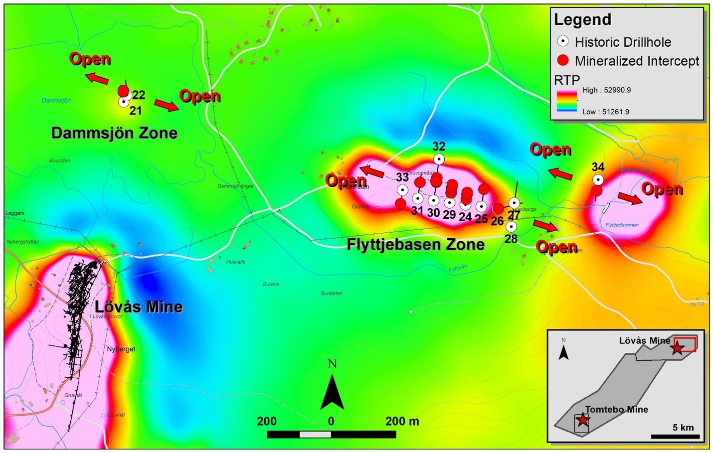
Table 3: Dammsjön and Flyttjebasen Zones Historical Drill Results
| Drill Hole | Depths and Interval | Historical Assay Results | |||||||||
| Hole ID | Azimuth | Dip | Depth (m) | From (m) | To (m) | Interval (m) | Zn (%) | Pb (%) | Cu (%) | Ag (g/t) | Au (g/t) |
| BH-21 | 356.8 | -50 | 63.28 | 47.39 | 63.28 | 15.89 | 0.63 | 0.26 | 1.26 | na | na |
| including | 47.39 | 48.75 | 1.36 | 3.02 | 0.45 | 3.25 | 62.00 | <0.1 | |||
| including | 50.31 | 52.65 | 2.34 | 0.60 | 0.72 | 3.68 | 70.00 | <0.1 | |||
| including | 62.57 | 63.28 | 0.71 | 0.30 | 0.10 | 2.50 | na | na | |||
| BH-22 | 356.8 | -70 | 140.11 | No significant mineralization encountered | |||||||
| BH-24 | 8.1 | -50 | 85.74 | 22.10 | 30.50 | 8.40 | 2.02 | 0.60 | 0.07 | 14.68 | <0.1 |
| 47.50 | 52.00 | 4.50 | na | 0.51 | 0.03 | 12.89 | <0.1 | ||||
| 51.30 | 52.00 | 0.70 | na | 2.30 | 0.07 | 40.00 | <0.1 | ||||
| 59.25 | 61.35 | 2.10 | 0.20 | 1.14 | na | 26.00 | <0.1 | ||||
| BH-25 | 8.1 | -50 | 120.70 | 83.20 | 88.00 | 4.80 | 1.12 | 1.84 | 0.06 | 44.27 | na |
| BH-26 | 76.3 | -50 | 126.00 | 3.34 | 7.00 | 3.66 | 0.72 | 0.38 | na | 5.07 | na |
| BH-27 | 8.1 | -50 | 106.67 | No significant mineralization encountered | |||||||
| BH-28 | 8.1 | -50 | 85.35 | No significant mineralization encountered | |||||||
| BH-29 | 8.1 | -50 | 108.54 | 44.50 | 49.60 | 5.10 | 0.44 | 0.13 | 0.07 | 5.23 | na |
| 65.35 | 67.75 | 2.40 | 1.20 | 0.34 | 0.04 | 1.00 | na | ||||
| 69.90 | 76.65 | 6.75 | 0.85 | 0.40 | 0.06 | 8.99 | na | ||||
| 78.20 | 97.65 | 19.45 | 0.81 | 0.22 | 0.18 | 5.14 | na | ||||
| BH-30 | 8.1 | -50 | 114.50 | 87.04 | 94.00 | 6.96 | 1.26 | 0.50 | na | 7.31 | na |
| 96.80 | 102.90 | 6.10 | 1.70 | 0.66 | na | 11.30 | na | ||||
| 109.30 | 114.50 | 5.20 | 1.38 | 0.21 | 0.08 | 5.88 | na | ||||
| BH-31 | 8.1 | -50 | 120.30 | 72.90 | 84.00 | 11.10 | 1.56 | 0.77 | 0.07 | 11.23 | na |
| 97.70 | 112.10 | 14.40 | 0.54 | 0.16 | na | 4.69 | na | ||||
| 115.70 | 119.20 | 3.50 | 0.54 | 0.09 | 0.05 | 7.00 | na | ||||
| BH-32 | 188.1 | -50 | 117.20 | 99.60 | 114.65 | 15.05 | 1.07 | 0.62 | na | 10.18 | na |
| including | 102.75 | 104.75 | 2.00 | 1.40 | 2.10 | <0.01 | 25.00 | na | |||
| BH-33 | 188.1 | -50 | 99.40 | 61.00 | 63.80 | 2.80 | 0.57 | 0.26 | 0.03 | 4.00 | na |
| 66.05 | 67.80 | 1.75 | 1.36 | 0.16 | 0.03 | 5.37 | na | ||||
| BH-34 | 188.1 | -50 | 102.36 | 53.56 | 54.38 | 0.82 | 1.47 | 1.05 | na | 24.00 | na |
| 60.85 | 64.60 | 3.75 | 0.29 | 0.19 | 0.13 | 8.00 | na | ||||
Notes:
- True widths of the reported mineralized intervals have not been determined.
- na - not assayed
- These drill results are historical in nature. District has not undertaken any independent investigation of the sampling nor has it independently analyzed the results of the historical exploration work in order to verify the results. The author of the NI 43-101 Technical Report on the Tomtebo Property has completed historical data verification and validation work, and has concluded that the historical drill results at the Tomtebo Mine do not conform to the presently accepted industry standards. District considers these historical drill results relevant as the Company will use this data as a guide to plan future exploration programs. The Company also considers the data to be reliable for these purposes, however, the Company's future exploration work will include verification of the data through drilling.
The Dammsjön zone is north of the former Lövås Mine and is dominated by copper mineralization with lesser zinc-lead mineralization that is wide open in all directions. Only select discrete intervals were assayed for silver and gold.
The Flyttjebasen zone is northeast-east from the former Lövås Mine, and is dominated by zinc-lead-silver mineralization with lesser copper mineralization that is wide open in all directions. Gold was often not assayed in this zone. Continuous mineralization strikes for 300 m at Flyttjebasen and step out hole BH-34 strongly suggests this zone continues at least an additional 310 m to the east.
Background on the Stollberg Property
The Stollberg Mineralized Trend is located in the Bergslagen region of the Fennoscandian shield. The field comprises a 5 km long steeply east-dipping belt of manganese-rich, magnetite and Zn-Pb-Ag sulphide deposits hosted by marble, skarn and hydrothermally altered meta-volcanic rocks. The deposits have been mined continuously from medieval times until 1982.
Most deposits in the Stollberg Mineralized Trend occur along the N-S striking eastern limb of an upright to steeply east-dipping, steeply south plunging syncline. The historic Gränsgruvan Zn-Pb-Ag Mine is located 2 km west of the historic Stollberg workings and is interpreted to be stratigraphically equivalent, representing the western limb of the syncline.
The core of the syncline comprises meta-sediments, which are separated from the mineralized horizon by 800 m of massive to banded rhyolitic meta-volcanic rocks. These hanging-wall rocks are generally not strongly altered but locally contain abundant patchy, calc-silicate aggregates and local zones of elevated cordierite, muscovite and quartz, interpreted as regional metamorphosed syn-volcanic alteration zones. Proximal to the ore horizon on the eastern limb, gradation into biotite+quartz-rocks with abundant porphyroblasts (locally more than 50 vol.%) of garnet, gahnite, cordierite, andalusite, sillimanite and amphibole is observed. These grade further eastward into marble and skarn, which is the main host to mineralization. Formation of these polymetallic deposits directly followed a major rhyolitic, volcanic eruption and formation of a submarine caldera. The earliest mineralization comprised exhalative iron oxides concurrent with limestone formation. Post-caldera subsidence and burial induced a shift in style of mineralization, whereby the limestone became a trap to replacement-type magnetite and Zn-Pb-Ag sulphide mineralization.
The polymetallic sulphide mineralization is dominated by sphalerite, pyrrhotite, arsenopyrite and lesser chalcopyrite and pyrite. They grade irregularly into semi-massive and locally massive sulphide bodies, which are considerably richer in galena (Pb-Ag). Average grades in the mined deposits ranged between 0.5 to 5% Zn, 0.5 to 15.6% Pb, and 5 to 320 g/t Ag13,14,15.
Boliden acquired the historic Gränsgruvan Zn-Pb-Ag Mine in 1972 and produced 0.26 Mt at 4.8% Zn, 2.1% Pb and 29 g/t Ag down to -225 m depth until mine closure in 197815. Boliden restarted exploration activities in the Stollberg Mineralized Trend in 2000.
Figure 7: Tomtebo and Stollberg Mineral Licenses
The newly discovered mineralization at the Västansjö deposit is situated on the eastern limb of the Stollberg syncline. A mineral resource estimate, compliant with SveMin’s procedures, was delineated by Boliden in 201616. Similarities in structural setting, alteration and mineralization style to the marble-skarn hosted Zn-Pb-Ag-(Cu-Au) deposit of Garpenberg imply potential for finding significant mineralization at the Stollberg Property13,14,15.
Recent Exploration Work
In 2006, approximately 20% of the Tomtebo Property was flown with SkyTEM (airborne electromagnetic survey), which at that time only had a depth penetration of approximately 200 m. The 2006 SkyTEM survey and a 2007 Induced Polarization (IP) survey was coincident with mineralization at the historic Tomtebo Mine at shallow depths, and also identified sub-parallel untested conductive anomalies.
In 2011, confirmatory drilling was conducted at the historic Tomtebo Mine with two shallow holes (less than 200 m deep each). Multiple untested projections of striking, dipping and plunging mineralization, and untested mineralized showings and conductive anomalies remain on the property.
From 2020 to Present, District has carried out geophysical, geochemical, geological mapping, and drill programs at Tomtebo that have returned positive results that indicate potential for the presence of a large polymetallic mineralized system on the Property.
From 2000 to 2016, Boliden carried out numerous geophysical, geochemical, geological mapping, and drill programs at Stollberg that have also returned positive results indicative to potentially host a large polymetallic mineralized system.
References:
1 Allen, R.L., Lundström, I., Ripa, M., and Christofferson, H., 1996, Facies analysis of a 1.9 Ga, continental margin, back-arc, felsic caldera province with diverse Zn-Pb-Ag-(Cu-Au) sulfide and Fe oxide deposits, Bergslagen region, Sweden: Economic Geology, v. 91, p. 979–1008.
2 https://www.boliden.com/490a73/globalassets/operations/exploration/mineral-resources-and-mineral-reserves-pdf/2023/resources-and-reserves-garpenberg-2023-12-31-1.pdf?v=102207
3 Ed. Eilu, Pasi, 2012, Geological Survey of Finland, Special Paper 53, Metallogenic areas in Sweden.
4 Geological Survey of Sweden report grb_097, 1997.
5 Daffern, T., Ellis, R., King, P., Richardson, S., Glucksman, E., Beveridge, A., 2017, NI 43-101 Technical Report for the Zinkgruvan Mine, Sweden, Wardell Armstrong International.
6 Raat, H., Jansson, N.F., and Lundstam, E., 2013, The Gränsgruvan Zn-Pb-Ag deposit, an outsider in the Stollberg ore field, Bergslagen, Sweden: Geology Applied to Mineral Deposits, Biennial Meeting, 12th, Uppsala, Sweden, August 12–15, 2013, Proceedings, p. 12–15.
7 Kopparberg Mineral (unpub. annual report, 2012)
8 Jansson, N.F., Sädbom, S, Allen, R.L, Billström, K, Spry, P.G., 2018, The Lovisa Stratiform Zn-Pb Deposit, Bergslagen, Sweden: Structure, Stratigraphy, and Ore Genesis: Economic Geology (2018) 113 (3): 699–739.
9 Sveriges Geologiska Undersökning (SGU) Map Viewer: https://apps.sgu.se/kartvisare/kartvisare-malm-mineral.html
10 Technical Report on Tomtebo Mine, Birger Hellegren, 1983.
11 Metal prices used in USD for the ZnEq calculation were based on Ag $15.00/oz, Au $1650/oz, Cu $2.15/lb, Zn $0.85/lb, and Pb $0.75/lb. ZnEq equals = Zn% + (Ag g/t × 0.0257) + (Au g/t x 2.831) + (Cu% × 2.529) + (Pb% × 0.882). The use of ZnEq is to calculate cut-off grades for exploration purposes, and no adjustments were made for metal recovery.
12 Metal prices used in USD for the CuEq cut-off calculation were based on Ag $15.00/oz, Au $1650/oz, Cu $2.15/lb, Zn $0.85/lb, and Pb $0.75/lb. CuEq equals = Cu% + (Au g/t x 1.1192) + (Ag g/t × 0.0102) + (Zn % x 0.3953) + (Pb % x 0.3488). The use of CuEq is to calculate cut-off grades for exploration purposes, and no adjustments were made for metal recovery.
13 Frank, K.S., Spry, P.G., Raat, H., Allen, R.A., Jansson, N.F and Ripa, M. (2019). Variability in the Geologic, Mineralogical, and Geochemical Characteristics of Base Metal Sulfide Deposits in the Stollberg Ore Field, Bergslagen District, Sweden. Econ Geol 114: 473–512. doi: https://doi.org/10.5382/econgeo.4646
14 Jansson N, Erismann F, Lundstam E, Allen RL (2013). Evolution of the Paleoproterozoic volcanic-limestone-hydrothermal sediment succession and Zn-Pb-Ag and iron oxide deposits at Stollberg, Bergslagen region, Sweden: Econ Geol 108: 309-335
15 Raat, H., Jansson, N.F., and Lundstam, E., (2013). The Gränsgruvan Zn-Pb-Ag deposit, an outsider in the Stollberg ore field, Bergslagen, Sweden: Geology Applied to Mineral Deposits, Biennial Meeting, 12th, Uppsala, Sweden, August 12–15, 2013, Proceedings, p. 12–15
16 Rönnblom-Pärson, E., (2016). Komplettering till ansökan om bearbetningskoncession Västansjö K nr 1, Smedjebackens Kommun, Dalarnas Län, 2016-02-29. Supporting document for mining concession application Västansjö K nr 1 from Boliden Mineral AB including a Mineral Resource Estimate to the Mining Inspectorate (Bergsstaten).