")
Sågtjärn – Sweden
Related News
All projects are advanced within Sweden’s defined mining legislation and environmental regulatory structure.
Overview
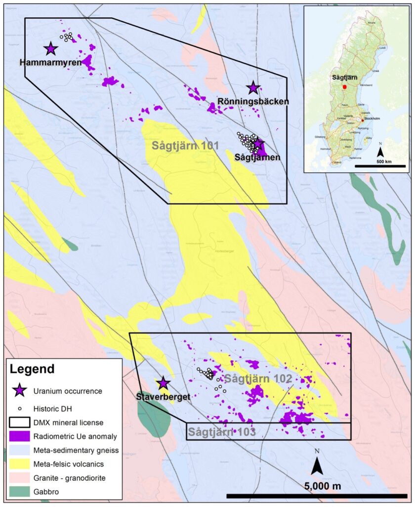
From May 2023 to November 2025, District Metals received approval from the Bergsstaten (Mining Inspectorate) for the Sågtjärn nr 101 to 103 mineral license applications to explore for metals and minerals over a 4,282 hectare (ha) area located in the Jämtland and Västernorrland Counties in central Sweden (Figure 1 and 2).
Sågtjärn Property Highlights
- Mineral license Sågtjärn nr 101 contains the Sågtjärn Uranium Deposit that contains an historical Inferred Mineral Estimate: 756,000 tonnes at a grade of 0.068% U3O8 containing 1,137,585 lbs of U3O8 using a 200 ppm uranium cut off1. This mineral resource estimate is considered to be an “historical estimate” under NI 43-101 and a qualified person has not done sufficient work to classify the historical estimate as a current mineral resource and District is not treating the historical estimate as a current mineral resource.
- See report titled “Revised Introductory Technical Report on Eight Uranium Properties in Northern Sweden” prepared for Continental Precious Metals Inc., revised and restated September 20, 2005 with an effective date of July 15, 2005 (the “Sågtjärn Report”).
- The Company views the historical estimate included in the Sågtjärn Report to be relevant and reliable.
- Based upon 47 drill holes, 50-100 m drill space fencing, 20-100 m spacing along drill fence. Partially drilled on a wide grid and is considered under-drilled. The authors of the Sågtjärn Report utilized a standardized cut-off of 300 ppm wherever possible to facilitate length weighted borehole grade and historical reserve comparisons.
- Sågtjärn Report resources are based on Geological Survey of Sweden (“SGU”) documentation and the auditing by the authors of the Sågtjärn Report of their ‘reserve’ calculation methodology, certain of the historical SGU estimates should be classified as (then) CIM-style inferred resources on the basis that these estimates are relevant and appear reliable.
- Both XRF analysis and pulse gamma logging were used in grade determinations, with the pulse gamma logging giving substantially higher volumes and grades. Despite this bias, the authors of the Sågtjärn Report (Forsberg and Kullman, 1981) believed that the pulse gamma logging results were more representative as they measured a greater rock volume.
- Forsberg and Kullman, 1981, calculated a wide variety of historical ‘reserve’ estimates, using a range of cut-off values (200 to 600 ppm in 100 ppm steps), analytical methods (XRF and PGL) and blocking techniques (profiles and triangles). is based on their profile method (for comparability with other deposit estimates), using a minimum 2 m ‘width’ and 300 ppm cut-off based on XRF analysis.
- It should be noted, however, that the bulk of the historical estimates, which serve as the basis for the Sågtjärn Report historical estimate, are based on volume weighted grades which do not take the log normal nature of the mineralization’s grade populations into account and that, due to this non-recognition of log normality, these historical grades are likely to be slightly overstated. It is impossible to judge the degree of grade overstatement without having carried out actual estimates, but it is considered unlikely (but not impossible) to exceed 10 % overall. This type of grade over reporting is a common problem with older, traditional reserve estimates and it was/is often accounted for by cutting high values.
- Mineral resources under the Sågtjärn Report were classified under previous definition standards and do not match the current categories under NI 43-101.
- The Company is not aware of any more recent estimates or data available to the Company on the Sågtjärn Uranium Property.
- The Company would need to conduct an exploration program, including twinning of historical drill holes in order to verify the Sågtjärn Uranium Property historical estimate as a current mineral resource.
- The mineral resource estimates is considered to be a “historical estimate” under NI 43-101 and a qualified person has not done sufficient work to classify the historical estimate as a current mineral resource and District is not treating the historical estimate as a current mineral resource.
- The Sågtjärn Deposit remains open in all directions, and contains the following drill result highlights:
- Hole SGT-77-007 intersected 8.7 m at 0.13% U3O8 from 60.3 to 69.0 m.
- Hole SGT-77-011 intersected 7.0 m at 0.18% U3O8 from 86.0 to 93.0 m.
- Hole SGT-79-011 intersected 5.2 m at 0.13% U3O8 from 132.6 to 137.8 m.
- Hole SGT-80-001 intersected 4.6 m at 0.13% U3O8 from 146.5 to 151.1 m.
The drill results can be found in the Geological Survey of Sweden (SGU) database: https://www.sgu.se/en/products/geological-data/. Drill results have been converted from U to U308 (U308=U*1.1792).
- Mineral license Sågtjärn nr 102 contains the Staverberget Mineral Occurrence, which is highlighted by:
- Historical boulders that returned assays from background levels up to 1.3% Cu, 1.8% Mo and 1.3 g/t Au.
- Limited historical drilling intersected 0.8 m at 1.46% U3O8, 1.26% Mo, 0.25% Pb, 0.2% Zn, 0.2% Cu, and 10 g/t Ag.
The Company is not treating the Sågtjärn Deposit as a mineral project material to the Company. District has not undertaken any independent investigation of the drill results nor has it independently analyzed the drill results in order to verify the results. District considers these drill results relevant as the Company is using this data as a guide to plan exploration programs. The Company’s current and future exploration work includes verification of the historical data through drilling.
Figure 1: Sågtjärn Property Location
Geological Setting
The regional geology where Sågtjärn is situated is part of the Sveckokarelian Province of the Precambrian Baltic Shield which runs from south of Stockholm to the far north of Sweden where Lapponian – Jatulian rocks of Archaean age occur. The Sveckokarelian province is bounded to the west by thrust nappes of sedimentary and volcanic rocks of Caledonian age and its eastern boundary lies across the Baltic Sea in Finland1.
The basement of the Svecokarelian Province developed before and in conjunction with the Svecokarelian orogenesis that occurred ~1,800 to 1,850 million years ago. The basement is dominated by plutonic rocks, usually granitoids, that are ~1,600 to 1,900 million years old, though successive generations of ‘post-orogenic’ or younger granites continued to be intruded until ~1,500 Mya and are found throughout the entire province. The earliest granitoids are believed to be of mantle origin, and have suffered high-grade metamorphism, anatexis and major deformation, whereas the younger granitoids believed to be of crustal origin, are largely unaffected2.
Dolerites are common intrusives occurring as dyke swarms of marking crustal sutures and major fracture zones throughout the area. They are aged ~900 to 1,500 million years ago1.
The supracrustal rocks of the Sveckokarelian Province are composed of Svecofennian terrestrial meta-sediments and metavolcanics dating from ~1,950 to 1,800 million years old. Basal meta-greywackes and meta-argillites predominate in the Svecofennian sedimentary rocks, with rare overlying meta-arenites, meta-arkoses and marbles. The stratigraphically higher metavolcanics are predominantly silicic to intermediate in composition e.g. metarhyolites; while basic metavolcanics occur towards the southeastern part of the province. In many cases, regional metamorphism was of such a high grade that the supracrustals have partly migmatised into gneisses.
Tectonism has commonly caused the supracrustals to become tightly folded, often with multiple generations of folding. Major regional fracture systems, generally trending north to northeastwards, developed during the major D2 deformational event some ~1,820 to 1,870 million years ago3.
The geologic sequence at Sågtjärn is composed of Proterozoic sedimentary “gneisses” which have undergone upper amphibolite facies metamorphism. The upper, biotite-rich “argillaceous” gneiss overlies a sillimanite bearing “arenitic” gneiss. Part of the meta-argillite has been skarnified, with the introduction of iron and minor scheelite mineralisation. Other rock types include remnants of basic dykes, granitic dykes and two types of pegmatoid, one of which hosts the mineralisation. The unmineralised granitic pegmatoid occupies over 20% of the rock volume at Sågtjärn4.
Figure 2: Sågtjärn Property Mineral Licenses
Sågtjärn Exploration History
The uranium occurrences on the Sågtjärn Property were discovered during follow-up work of geochemical soil anomalies in 1974 by the Swedish Geological Survey (SGU). Detailed outcrop mapping, boulder hunting and sampling started in 1975 followed by ground geophysical surveys and systematic geochemical sampling.
Drilling commenced in 1977 and was completed in early Spring 1980. Forty-three diamond drill and four percussion holes were drilled during this period giving a total of 6,655 m at the Sågtjärn Uranium Deposit.
The Sågtjärn Uranium Deposit remains open in all directions, especially towards the northwest where historical hole SGT-80-001 intersected 4.6 m at 0.13% U3O8 from 146.5 to 151.1 m. The drill results can be found in the Geological Survey of Sweden (SGU) database: https://www.sgu.se/en/products/geological-data/. Drill results have been converted from U to U308 (U308=U*1.1792). The historical drill cores have not been analyzed for other potentially economic elements of interest.
Multiple companies historically explored the Sågtjärn area for base- and precious metals. This includes the Staverberget area with copper, molybdenum, and gold enriched boulders that assayed from background levels to 1.3% Cu, 1.8% Mo and 1.3 g/t Au hosted by metamorphosed, fine-grained mica-rich sediment-gneiss. Follow-up drilling in 1982 (987 m in 7 drill holes) intersected a 0.8 m mineralized interval with 1.46% U3O8, 1.26% Mo, 0.25% Pb, 0.2% Zn, 0.2% Cu, 10 g/t Ag5. The drill results can be found in the Geological Survey of Sweden (SGU) database: https://www.sgu.se/en/products/geological-data/. Drill results have been converted from U to U308 (U308=U*1.1792).
The last company who held mineral licenses covering the Sågtjärn Property was Continental Precious Minerals from 2005 to 2014 where they drilled one hole (SGT-07-001) in the center of the Sägtjärn Uranium Deposit that returned confirmatory assay results. No modern exploration techniques including geophysics have been applied on the Sågtjärn Property.
Sågtjärn Deposit
The Sågtjärn Uranium Deposit covers an area of approximately 700 by 400 m, which remains open in all directions. The deposit is situated in a broad valley bottom with numerous small lakes and marshes. A small part of the deposit outcrops but most of the area is covered with glacial till to depths of up to 8 m. The deposit is under drilled4.
The wall rock structure is that of an open flat synformal fold structure whose axis dips gently (~10°) towards the northwest. The skarn lies in the meta-argillites, just above the meta-arenite and, based on drill sections, appears to be largely stratiform. The mineralised pegmatoids occur as irregular sheetlike zones crosscutting the gneisses and the skarn. They strike west-northwesterly (N60°W) and generally dip at 40 to 60° towards the southwest that further shallow towards the southwest of the deposit4.
The uranium bearing pegmatoids are usually coarse grained, biotite-rich, quartz-feldspar rocks with minor quantities of chalcopyrite, molybdenite and monazite. Uranium has an affinity for biotite in which it tends to be concentrated. The primary uranium mineral is uraninite, which is commonly interstitially veined with radiogenic lead. Secondary uranium minerals occur within boulders and in outcrops.
Minor quantities of scheelite occur within narrow “low-grade” lenses within the skarn horizon where XRF tungsten analysis from some of the better mineralised portions of the core varies from 11 to 1,890 ppm4.
The Sågtjärn Deposit is under drilled due to the curtailment of the SGU’s uranium exploration program. It is open both along strike and down dip, as well as requiring a number of infill holes to tighten up the historical inferred mineral resource estimate4.
Exploration activities are conducted under defined permits issued in accordance with Swedish mining legislation and environmental regulations. Activities are time-bound and subject to oversight by relevant national and regional authorities.
References
2 Lundqvist T., and Bygghammar, B., 1994 “The Swedish PreCambrian” in Geology : National Atlas of Sweden. Editor Fredén, C.. Royal Swedish Academy of Sciences. First Edition, 208 pgs.
3 Weihed, J.B., 2001 Palaeproterozoic deformation zones in the Skellefte and Arvidsjaur areas, northern Sweden. In Weihed J., (Editor) Economic geology Research. Vol. 1, 1999-2000. Uppsala 20001. Sveriges Geologiska Undersökning, C 833, pgs 46 to 68.
4 Forsberg, L-O. and Kullman, F., 1981: Sågtjärnen, Detailed Prospecting and Ore Estimation. Uranrapport 1981-3, Sveriges Geologiska Undersökning, BRAP 81033, p. 73. 5 Persson, G., 1983: Molybdenminerliseringen Steverbergt. Prospekteringsrapport, Sveriges Geologiska Undersökning, BRAP 82601, p. 45.