District Intersects 14.3 m at 14.2% ZnEq on the Tomtebo Property
November 22, 2021 – District Metals Corp. (TSX-V: DMX) (FRA: DFPP); ("District" or the “Company”) is pleased to report assay results for the first three drill holes from the Phase II drill program at the high grade polymetallic Tomtebo Property located in the Bergslagen Mining District in south-central Sweden.
Drill holes TOM21-024 and -025 targeted the Steffenburgs zone down plunge from hole TOM21-001 (previously reported here), which returned 8.2 m at 20.94% ZnEq1 from 65.3 to 73.5 m (Figure 1). Hole TOM21-025 encountered 11.0 m of massive sulphide mineralization (211.4 to 222.4 m) located 118 m down plunge from TOM21-001. Hole TOM21-023A/B targeted a coincident gravity and magnetic anomaly located 1.0 km northeast from the historic Tomtebo Mine.
Highlights:
- TOM21-025 intersected 14.3 m at 14.2% ZnEq1 (210.0 to 224.3 m).
- including 11.6 m at 16.9% ZnEq1 (210.8 to 222.4 m).
- including 6.6 m at 21.6% ZnEq1 (212.8 to 219.4 m).
- TOM21-024 intersected 3.25 m at 5.6% ZnEq1 (110.55 to 113.80 m).
A drill hole cross section is shown in Figure 1, and drill assay results are shown in Table 1.
Rodney Allen, Technical Advisor for District, commented: “The intersections in holes TOM21-001 and TOM21-025 are classic volcanogenic massive sulphide (VMS) of good metal grade. As is normal for VMS, pyrite is the main sulphide mineral, followed in abundance by sphalerite (zinc), galena (lead) and chalcopyrite (copper), silver and gold. From interpretation of the geology of the Tomtebo area, we conclude that the massive sulphide lens formed at or just below the sea floor in the vent of a submarine volcano, 1.9 billion years ago. The southwest side of the massive sulphide lens grades into an extensive network of pyritic polymetallic vein mineralization that is interpreted to represent sulphide precipitated in the “feeder conduits”, below the massive sulphide (figure 1). The northeast side of the massive sulphide lens has a sharp contact with less mineralized hanging-wall volcanic rocks and is interpreted to be the original top of the massive sulphide body. The lateral edges of the massive sulphide are not yet well defined and we are uncertain whether these edges are the natural lateral termination of the original massive sulphide or whether they are tectonically truncated margins, for example faults. The down-plunge extent of the massive sulphide is open.
Like all rocks in the Tomtebo area, the massive sulphide lens has been stretched and folded by subsequent tectonic deformation. Each drill hole we put down in the Steffenburgs area provides more evidence of the shape and extent of this deformed massive sulphide body. From the data assembled so far, we interpret that the massive sulphide lens has been stretched into an elongate shape with a moderate to steep plunge to the north. The lens is directly adjacent to, and probably in part within, the “nose” or “closure” of a tight fold and consequently the shape of the lens is not expected to be a simple disk or ellipse. Current evidence suggests that the lens is narrow near surface but widens with depth.”
Garrett Ainsworth, CEO of District, commented: “Our drill assay results associated with visually strong sulphide mineralization encountered in holes TOM21-024 and -025 are even better than anticipated, and the high grade polymetallic lenses currently being delineated at the Steffenburgs zone are impressive. Hole -025 is an aggressive 118 m step out down plunge from hole -001 where down-hole electromagnetic surveys and whole rock geochemistry will provide important inputs to our 3D model that will assist with continuing to step out aggressively at depth.”
Figure 1: Cross Section Looking Northwest at Steffenburgs Zone
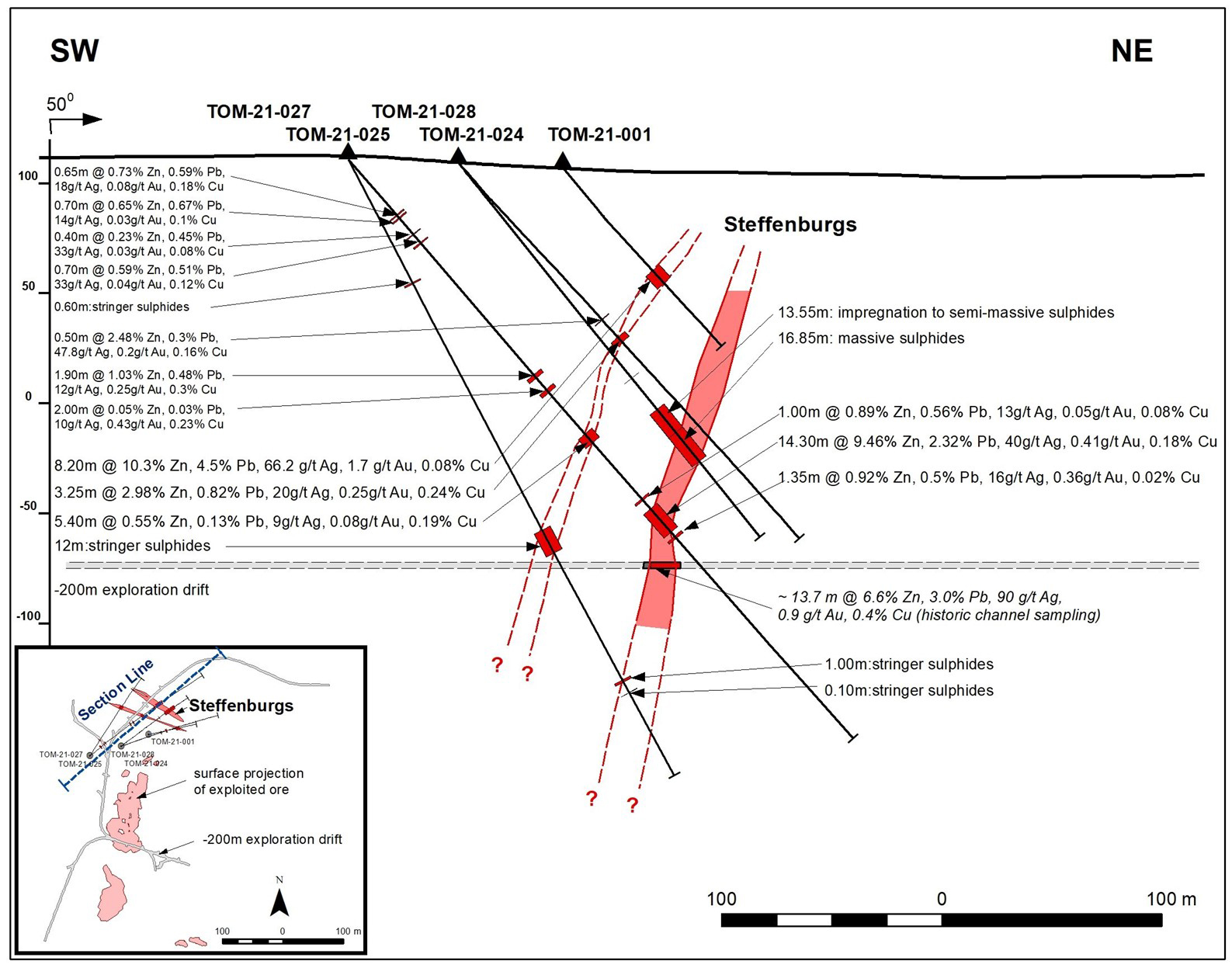
Table 1: Tomtebo Drill Assay Results
| Drill Hole | Depths and Interval | Assay Results | ||||||||||
| Hole ID | Azimuth | Dip | Total Depth (m) |
From (m) | To (m) | Interval (m) |
Ag (g/t) | Zn (%) | Pb (%) | Au (g/t) | Cu (%) | ZnEq (%) |
| TOM21-023A/B | 145 | -45 | 399.00 | No Significant Results | ||||||||
| TOM21-024 | 70 | -45 | 239.20 | 99.30 | 99.80 | 0.50 | 47.80 | 2.48 | 0.30 | 0.20 | 0.16 | 4.97 |
| 110.55 | 113.80 | 3.25 | 20.18 | 2.98 | 0.82 | 0.25 | 0.24 | 5.55 | ||||
| TOM21-025 | 52 | -48 | 351.00 | 33.30 | 33.95 | 0.65 | 18.45 | 0.73 | 0.59 | 0.08 | 0.18 | 2.43 |
| 35.00 | 35.70 | 0.70 | 13.55 | 0.65 | 0.67 | 0.03 | 0.10 | 1.93 | ||||
| 44.90 | 45.30 | 0.40 | 33.40 | 0.23 | 0.45 | 0.03 | 0.08 | 1.79 | ||||
| 49.90 | 50.60 | 0.70 | 32.50 | 0.59 | 0.51 | 0.04 | 0.12 | 2.27 | ||||
| 129.15 | 131.05 | 1.90 | 12.10 | 1.03 | 0.48 | 0.25 | 0.30 | 3.25 | ||||
| 138.00 | 140.00 | 2.00 | 9.69 | 0.05 | 0.03 | 0.43 | 0.23 | 2.13 | ||||
| 164.80 | 170.20 | 5.40 | 9.22 | 0.55 | 0.13 | 0.08 | 0.19 | 1.62 | ||||
| 204.00 | 205.00 | 1.00 | 12.75 | 0.89 | 0.56 | 0.05 | 0.08 | 2.06 | ||||
| 210.00 | 224.30 | 14.30 | 40.00 | 9.46 | 2.32 | 0.41 | 0.18 | 14.15 | ||||
| incl. | 210.80 | 222.40 | 11.60 | 46.60 | 11.50 | 2.72 | 0.45 | 0.20 | 16.89 | |||
| incl. | 212.80 | 219.40 | 6.60 | 46.12 | 15.95 | 3.01 | 0.49 | 0.16 | 21.59 | |||
| 226.65 | 228.00 | 1.35 | 16.30 | 0.92 | 0.50 | 0.36 | 0.02 | 2.87 | ||||
Notes:
- All intervals are core lengths, and true thicknesses are yet to be determined. Mineral resource modeling is required before true thicknesses can be estimated.
- Cut-off grade of 1.2% ZnEq was utilized, which may include up to 2.0 m of internal dilution. Underground mining cut-off at the nearby Garpenberg Mine was US$32/tonne in 2020.
- Metal prices used in USD for the ZnEq cut-off calculations were based on Ag $15.00/oz, Au $1650/oz, Cu $2.15/lb, Zn $0.85/lb, and Pb $0.75/lb.
- ZnEq = Zn% + (Ag g/t × 0.0257) + (Au g/t x 2.831) + (Cu% × 2.529) + (Pb% × 0.882)
- The use of ZnEq is to calculate cut-off grades for exploration purposes, and no adjustments were made for metal recovery.
Drill Hole Summaries
TOM21-023B (Northeast gravity target):
Hole TOM21-023B was drilled at an angled orientation (-45° dip) to the southeast (145° azimuth). It was designed to test a blind gravity high anomaly with coincident magnetic and conductive anomalies located 1 km northeast along trend from the historic Tomtebo Mine. Hole TOM21-023A was lost at a depth of 42.0 m, and TOM21-023B was the re-start hole.
After 16.0 m of overburden, the hole intersected weakly altered (silicified, biotite, and albite) felsic volcanic rocks with no sulphides that was intercalated with mafic dykes from 16.0 to 217.0 m. A dyke swarm with an increased magnetic response comprised of amphibolite, porphyritic, and diabase dykes within an interbedded silicified volcanic ash was encountered from 217.0 to 244.0 m that transitioned back into weakly altered felsic volcanic rocks from 244.0 to 275.0 m. This package was underlain by an undifferentiated intrusive unit from 275.0 to 354.0 m, which appears to be of dioritic composition, and is denser than the surrounding felsic volcanic rocks. From 354.0 to 386.0 a weakly altered felsic volcanic rock with meter-scale mafic dykes is present, where a dense mafic intrusion (gabbro?) with intersecting mafic dykes persists from 386.0 to the end of hole depth at 399.0 m. The magnetic and gravity anomalies have been explained by the slightly magnetic dyke swarm and dense diorite/gabbro intrusions, respectively.
TOM21-024 (Steffenburgs zone):
Hole TOM21-024 was drilled at an angled orientation (-45° dip) to the east-northeast (70° azimuth). It was designed to step out 40 m down plunge from massive sulphides encountered in hole TOM21-001, which returned 8.2 m at 10.3% Zn, 4.5% Pb, 66.2 g/t Ag, 1.7 g/t Au, and 0.08% Cu (65.3 to 73.5 m).
After 18.8 m of overburden, the hole intersected moderately altered felsic volcanic rocks with trace pyrite (1 to 3%) from 18.8 to 85.0 m. A porphyritic mafic dike was encountered from 85.0 to 92.55 m. Moderately to strongly altered felsic rock with increasing pyrite, pyrrhotite and magnetite content was intersected between 92.55 to 210.4 m highlighted by vein/stringer sulphides from 92.55 to 98.2 m, and disseminated to semi-massive sulphides (pyrrhotite, pyrite, sphalerite, chalcopyrite, galena) from 109.2 to 113.8 m. Weakly to moderately altered felsic rock with trace pyrite (0.1%) persisted from 210.4 to the end of hole depth at 239.2 m. Hole TOM21-024 was drilled just south of the northwest plunging massive sulphide lens encountered in hole TOM21-001 and -025, so a follow up hole in this area is planned.
TOM21-025 (Steffenburgs zone):
Hole TOM21-025 was drilled at an angled orientation (-48° dip) to the northeast (52° azimuth). It was designed to step out 118 m down plunge from massive sulphides encountered in hole TOM21-001, which returned 8.2 m at 10.3% Zn, 4.5% Pb, 66.2 g/t Ag, 1.7 g/t Au, and 0.08% Cu (65.3 to 73.5 m).
After 15.9 m of overburden, the hole intersected moderately altered felsic volcanic rocks with trace pyrite (1%) from 15.9 to 136.0 m with occasional meter-scale mafic dykes. Moderately to strongly altered felsic rock with increasing pyrite, pyrrhotite and magnetite content was intersected between 136.0 to 211.4 m. Massive sulphides (sphalerite, galena, pyrite, pyrrhotite, chalcopyrite) were intersected from 211.4 to 222.4 m. This high grade and very dense mineralized intercept is underlain by moderately altered felsic volcanic rocks with occasional meter-scale mafic dykes from 222.4 to 260.0 m where weakly altered felsic volcanic rocks continue from 260.0 m to the end of hole depth at 350.0 m. Hole TOM21-025 represents the best drill assay interval intersected at the historic Tomtebo Mine to date.
References
1 Metal prices used in USD for the ZnEq calculation were based on Ag $15.00/oz, Au $1650/oz, Cu $2.15/lb, Zn $0.85/lb, and Pb $0.75/lb. ZnEq equals = Zn% + (Ag g/t × 0.0257) + (Au g/t x 2.831) + (Cu% × 2.529) + (Pb% × 0.882). The use of ZnEq is to calculate cut-off grades for exploration purposes, and no adjustments were made for metal recovery.
Technical Information
All scientific and technical information in this news release has been prepared by, or approved by Garrett Ainsworth, PGeo, President and CEO of the Company. Mr. Ainsworth is a qualified person for the purposes of National Instrument 43-101 - Standards of Disclosure for Mineral Projects.
The drill core reported in this news release was logged and prepared at the District Metals AB core facility in Säter, Sweden before submittal to ALS Geochemistry in Malå, Sweden where the NQ-size drill core is cut, bagged, and prepared for analysis. Sample pulps were sent to ALS Geochemistry in Ireland (an accredited mineral analysis laboratory) for analysis. Samples were analyzed using a multi-element ultra trace method combining a four-acid digestion with ICP-MS analytical package (“ME-MS61”). Over limit sample values were re-assayed for: (1) values of copper >1%; (2) values of zinc >1%; (3) values of lead >1%; and (4) values of silver >100 g/t using the high-grade material ICP-AES analytical package (“ME-OG62”). Additional over limit sample values were re-assayed for: (1) values of zinc >30%; (2) values of lead >20% using the high precision analysis of base metal ores AAS analytical package (“Zn, Pb-AAORE”). Gold, platinum, and palladium were analyzed using the 30 g lead fire assay with ICP-AES finish analytical package (“PGM-ICP23”). Certified standards, blanks, and duplicates were inserted into the sample shipment to ensure integrity of the assay process. Selected samples were chosen for duplicate assay from the coarse reject and pulps of the original sample. No QA/QC issues were noted with the results reported.
Some of the data disclosed in this news release is related to historical drilling results. District has not undertaken any independent investigation of the sampling nor has it independently analyzed the results of the historical exploration work in order to verify the results. District considers these historical drill results relevant as the Company is using this data as a guide to plan exploration programs. The Company's current and future exploration work includes verification of the historical data through drilling.
Mr. Ainsworth has not verified any of the information regarding any of the properties or projects referred to herein other than the Tomtebo Property. Mineralization on any other properties referred to herein is not necessarily indicative of mineralization on the Tomtebo Property.
About District Metals Corp.
District Metals Corp. is led by industry professionals with a track record of success in the mining industry. The Company’s mandate is to seek out, explore, and develop prospective mineral properties through a disciplined science-based approach to create shareholder value and benefit other stakeholders.
The advanced exploration stage Tomtebo Property is located in the Bergslagen Mining District of south-central Sweden is the Company’s main focus. Tomtebo comprises 5,144 ha and is situated between the historic Falun Mine and Boliden’s Garpenberg Mine that are located 25 km to the northwest and southeast, respectively. Two historic polymetallic mines and numerous polymetallic showings are located on the Tomtebo Property along an approximate 17 km trend that exhibits similar geology, structure, alteration and VMS/SedEx style mineralization as other significant mines within the district. Mineralization that is open at depth and along strike at the historic mines on the Tomtebo Property has not been followed up on, and modern systematic exploration has never been conducted on the Property.
For further information on the Tomtebo Property, please see the technical report entitled “NI 43-101 Update Technical Report on the Tomtebo Project, Bergslagen Region of Sweden” dated effective October 15, 2020 and amended and restated on February 26, 2021, which is available on SEDAR at www.sedar.com.
On Behalf of the Board of Directors
“Garrett Ainsworth”
President and Chief Executive Officer
(604) 288-4430
Neither TSX Venture Exchange nor its Regulation Services Provider (as that term is defined in policies of the TSX Venture Exchange) accepts responsibility for the adequacy or accuracy of this release.
Cautionary Statement Regarding “Forward-Looking” Information.
This news release contains certain statements that may be considered “forward-looking information” with respect to the Company within the meaning of applicable securities laws. In some cases, but not necessarily in all cases, forward-looking information can be identified by the use of forward-looking terminology such as “plans”, “targets”, “expects” or “does not expect”, “is expected”, “an opportunity exists”, “is positioned”, “estimates”, “intends”, “assumes”, “anticipates” or “does not anticipate” or “believes”, or variations of such words and phrases or statements that certain actions, events or results “may”, “could”, “would”, “might”, “will” or “will be taken”, “occur” or “be achieved” and any similar expressions. In addition, any statements that refer to expectations, predictions, indications, projections or other characterizations of future events or circumstances contain forward-looking information. Statements containing forward-looking information are not historical facts but instead represent management’s expectations, estimates and projections regarding future events. Forward-looking statements in this news release relating to the Company include, among other things, statements relating to the Company’s planned exploration activities, including its drill target strategy and next steps for the Tomtebo Property; the company’s interpretations and expectations about the mineralization of the Tomtebo Mine; the Company’s belief that the numerous gravity high anomalies identified at the historic Tomtebo Mine provide immense expansion potential; the Company’s belief that the modeled gravity high anomalies at the historic Tomtebo Mine could correspond with polymetallic and/or iron sulphide mineralization, or a mafic unit; and the Company’s belief that the gravity high anomaly located one kilometer to the northeast of the Tomtebo Mine represents a potential grassroots discovery opportunity with a modeled tonnage that compares with the historic production tonnage from the historic Falun Mine.
These statements and other forward-looking information are based on opinions, assumptions and estimates made by the Company in light of its experience and perception of historical trends, current conditions and expected future developments, as well as other factors that the Company believes are appropriate and reasonable in the circumstances, as of the date of this news release, including, without limitation, assumptions about the reliability of historical data and the accuracy of publicly reported information regarding past and historic mines in the Bergslagen district; the Company’s ability to raise sufficient capital to fund planned exploration activities, maintain corporate capacity and satisfy the exploration expenditure requirements required by the definitive purchase agreement between the Company and the vendor of the Tomtebo Property (the "Tomtebo Purchase Agreement") by the times specified therein; and stability in financial and capital markets.
Forward-looking information is necessarily based on a number of opinions, assumptions and estimates that, while considered reasonable by the Company as of the date such statements are made, are subject to known and unknown risks, uncertainties, assumptions and other factors that may cause the actual results, level of activity, performance or achievements to be materially different from those expressed or implied by such forward-looking information, including but not limited to risks associated with the following: the reliability of historic data regarding the Tomtebo Property; the Company’s ability to raise sufficient capital to finance planned exploration (including incurring prescribed exploration expenditures required by the Tomtebo Purchase Agreement, failing which the Tomtebo Property will be forfeited without any repayment of the purchase price); the Company’s limited operating history; the Company’s negative operating cash flow and dependence on third-party financing; the uncertainty of additional funding; the uncertainties associated with early stage exploration activities including general economic, market and business conditions, the regulatory process, failure to obtain necessary permits and approvals, technical issues, potential delays, unexpected events and management’s capacity to execute and implement its future plans; the Company’s ability to identify any mineral resources and mineral reserves; the substantial expenditures required to establish mineral reserves through drilling and the estimation of mineral reserves or mineral resources; the Company’s dependence on one material project, the Tomtebo Property; the uncertainty of estimates used to calculated mineralization figures; changes in governmental regulations; compliance with applicable laws and regulations; competition for future resource acquisitions and skilled industry personnel; reliance on key personnel; title matters; conflicts of interest; environmental laws and regulations and associated risks, including climate change legislation; land reclamation requirements; changes in government policies; volatility of the Company’s share price; the unlikelihood that shareholders will receive dividends from the Company; potential future acquisitions and joint ventures; infrastructure risks; fluctuations in demand for, and prices of gold, silver and copper; fluctuations in foreign currency exchange rates; legal proceedings and the enforceability of judgments; going concern risk; risks related to the Company’s information technology systems and cyber-security risks; and risk related to the outbreak of epidemics or pandemics or other health crises, including the recent outbreak of COVID-19. For additional information regarding these risks, please see the Company’s Annual Information Form, under the heading “Risk Factors”, which is available at www.sedar.com. These factors and assumptions are not intended to represent a complete list of the factors and assumptions that could affect the Company. These factors and assumptions, however, should be considered carefully. Although the Company has attempted to identify factors that would cause actual actions, events or results to differ materially from those disclosed in the forward-looking statements or information, there may be other factors that cause actions, events or results not to be as anticipated, estimated or intended. Also, many of such factors are beyond the control of the Company. Accordingly, readers should not place undue reliance on forward-looking statements or information. The forward-looking information is made as of the date of this news release, and the Company assumes no obligation to publicly update or revise such forward-looking information, except as required by applicable securities laws. All scientific and technical information contained in this news release has been prepared by or reviewed and approved by Garrett Ainsworth, PGeo, President and CEO of the Company. Mr. Ainsworth is a qualified person for the purposes of National Instrument 43-101 - Standards of Disclosure for Mineral Projects.